

Plans have been submitted for a path intended to help a council create “20 minute neighbourhoods” where people can easily reach shops and services on foot.
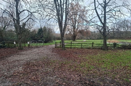
The 500-metre long path will run through the grounds of Caldicot Castle and is intended to create a traffic free route for pedestrians, cyclists and wheelchair users to get around Caldicot and surrounding villages including Caerwent, Portskewett, Crick and Sudbrook.
The council’s yet to be approved replacement local development plan is also proposing allocating land for up to 700 new homes east of Caldicot and north of Portskewett, with the plan intending new housing is built within 20 minutes walking distance of existing shops and services.
The council has submitted an application to its planning department for approval for the path which would follows the existing maintenance path on the eastern side of the castle grounds, before following informal and well-used paths in the grounds to connect with existing walking and cycling paths around the town formally known, by the council, as the phase one Caldicot Links active travel routes.
It is expected as many as 200 people an hour could use the new 2.5 metres wide formal route through the castle grounds which will run through Caldicot Castle Country Park, to the east of the castle and Nedern Brook, and to the west of Caldicot Bypass, the B4245.
It is accepted in the application that parts of the new ground level path will flood following as the country park is within a flood zone.
Raising the ground level was ruled out to avoid increasing the flooding risk and impacts on the local area while a boardwalk-type feature was dismissed as both impractical and visually impactful.
Users will be directed to existing alternative routes that can be used if the path is flooded.
The path will have an asphalt surface, including buff-coloured in parts as a nod to the “yellow hues of the castle stone”, according to the council’s application form.
That states the path will provide an “improved ride comfort for cyclists, as well as offering greater weather-resistance for all users”.
Detailed reports on the visual impact, landscaping, drainage and how the council consulted on its plans are included with the planning application.
A design statement included states the path will assist Monmouthshire County Council in “creating 20-minute neighbourhoods for both current and future residents and promotes cohesive communities where active travel is the preferred option for trips under three miles”.
The application is being considered by the council planning department.
 Mother who held woman captive as a slave for 25 years jailed
 Council appoints contractor to begin delivery of Hereford Bypass
 Culture bids ‘must benefit county regardless of outcome’
 Hereford pensioner despairs of Blue Badge renewal
 Eight-figure sum quoted to fix Ledbury station access
 Road patched over 200 times ‘still dangerous’
 Herefordshire households to pay £20 more for police and fire
 Pegasus FC cruise to huge win over Worcester Raiders in the Uhlsport Hellenic League Marsh Challenge Cup Semi Final
